Portrait of Change 1760-1860
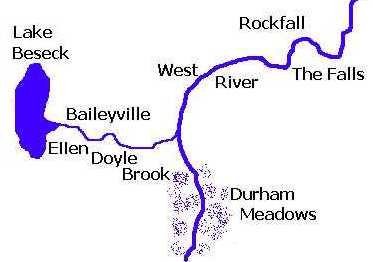
During the first portion of the Industrial Revolution (1760-1860) Middlefield changed from an agricultural village to an industrial leader. Lead by hardworking industrious men the north flowing West River (Coginchaug) and it tributary the Beseck River (Ellen Doyle Brook) became the centers of this development. By the 1840's, with two dammed water sources, Middlefield represented the best industrial development in the Northeast. Along the way the town also had a hand in some of the important developments that helped fuel the industrial growth of the young United States. Middlefield developed around two locations on these rivers: Baileyville in the southern section of town and Rockfall in the northeast section. This development began at Wildcat Swamp (Lake Beseck) and flowed with many interesting turns to the Middletown border.